What do the characters in The Grapes of Wrath, Icelandic shepherds in the Middle Ages and ancient Peruvians have in common? They all suffered from the effects of intensive agriculture on sensitive environments.

Throughout human history unsustainable agricultural practices have turned fragile ecosystems into wastelands and left people starving. During the Dust Bowl, American farmers learned the consequences of removing the deep rooted grasses from the
The ancient inhabitants of what is now
People were able to raise a variety of crops there for several centuries. But intensive agriculture in pre-conquest times led to ecosystem collapse. The history of the land was recently reconstructed by bioarcheologist David Beresford-Jones of the
Beresford-Jones and a team of archeologists studied plant remains associated with settlement sites spanning roughly 750 B.C. to 1000 A.D. They observed the change as the valley inhabitants went from eating mostly gathered foods, to a period of intense agriculture, then back again to surviving on what they could eke out of nature's diminished bounty.
"The farmers inadvertently crossed an ecological threshold and the changes became irreversible," says Dr. David Beresford-Jones of the
BLOG: Civilization Collapsed After Cutting Key Trees
 Valley was possible because of the huarango tree woodland, which literally held the floodplain together. The roots of the tree physically anchored the soils and protected the ground from erosion. The trees also maintained fertility by fixing nitrogen from the air and keeping moisture in the soil.
But as more land was cleared for crop production, so much of the woodland was cleared that the huarango's benefits were lost. The land was then exposed to floods from El Niño events and strong winds parched the land when it wasn't flooded.
BLOG: El Niño Link Between Peru and Montana
Clearing the land of trees in order to grow crops had inadvertently and ironically made it impossible to grow crops.
Earlier residents of the valley had survived largely on land snails, along with sea urchins and mussels gathered from the Pacific coast, an eight-hour walk to the west. The researchers found no evidence of domesticated crops in the refuse heaps, called middens, left by these early inhabitants.
Things started to change around 100 B.C. Remains from crops, including pumpkins, maize, and manioc tubers, began appearing in the garbage heaps. Within a few hundred years there was more intensive agriculture. People added beans, peanuts, and chili peppers to their menus.
The feast didn't last long though. After about 500 years of agriculture, the domesticated crops disappeared. People once again survived on only snails and seafood with some wild plants.
In less than two thousand years, the people went full circle and ended up eating what their ancestors had, but without the huarango forests. To this day, the land is barren, with only the ghostly outlines of irrigation canals to suggest that the land once supported an agrarian society.
Further evidence of the change is found in the disappearance of the use of a blue dye from the indigofera shrub. The shrub grows only in the shelter of huarango trees along waterways. The peoples of the
The indigofera eventually disappeared from the lower
The study of land use in the
BLOG: Foggy Notions for a Thirsty World
The peoples of the
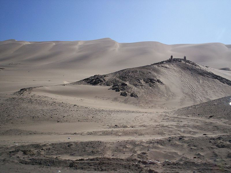
IMAGE 1: The coastal
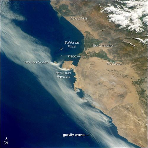
IMAGE 2: Photo STS109-730-80 from the STS-109 crew on March 9, 2002, showing layers of coastal Peruvian fog and stratus being progressively scoured away by brisk south to southeast winds. Remnants of the cloud deck banked against the larger, obstructing headlands like Peninsula Paracas and Isla Sangayan, giving the prominent “white comma” effect. Southerlies also produced ripples of internal gravity waves in the clouds offshore where warm, dry air aloft interacts with a thinning layer of cool, moist air near the sea surface on the outer edge of the remaining cloud bank. South of Peninsula Baracas, the small headlands channeled the clouds into streaks—local horizontal vortices caused by the headlands provided enough lift to give points of origin of the clouds in some bays. Besides the shelter of the peninsula, the Bahia de Pisco appears to be cloud-free due to a dry, offshore flow down the valley of the Rio Ica. Caption provided by NASA Earth Observatory; image provided by the Earth Sciences and Image Analysis Laboratory at

 Previous page
 Back to top


